1/16


AviNavi, navigation for pilots
1K+ダウンロード
29MBサイズ
4.5.7(08-01-2024)最新バージョン

詳細レビューバージョン情報
1/16
AviNavi, navigation for pilotsの説明
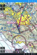
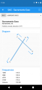
航空航法はシンプルで手頃な価格になりました。米国本土のすべてのVFR、低高度IFR、計器進入方式のチャート。航空路ナビゲーションのサポートを含む完全な飛行計画が含まれています。 Nexrad、METAR、およびAIRMETS / SIGMETSのオーバーレイにより、飛行の安全性が向上し、詳細な空港情報(滑走路、周波数、燃料、天気)がすぐに利用できます。
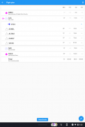
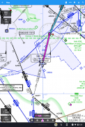
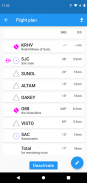
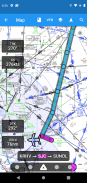
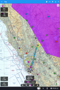
移動する地図を使用して、空港、VOR、NDB、または交差点を検索または選択し、直接ナビゲーションを開始するか、フライトプランに追加します。または、フライトプランをテキストで入力します。例: KPAO SUNOL V334 SAC KSACは、すべての航空路ナビゲーションポイントを含む完全な飛行計画をロードします。
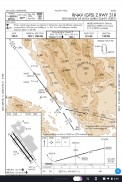
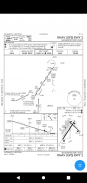
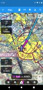
計器進入チャートには、空港図、STARS、DP、最小値、および凡例が含まれています。
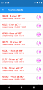
近くの空港は緑または赤で表示され、それらの空港が無風滑走で到達可能であるかどうかを示します。
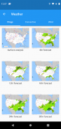
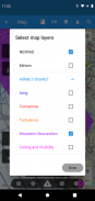
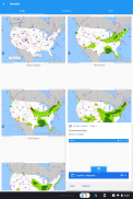
METAR、TAF、AIRMET、SIGMET、Progチャート、Convective Outlook、Windは、グラフィックおよび/またはテキスト情報として利用できます。 METARとAIRMETS / SIGMETSは、[レイヤー]ボタンを使用してマップにオーバーレイできます。空港情報では、METARとTAFが平易な英語で表示され、Progチャート、さまざまな時間と高度の対流見通しと風のグラフィックがフルスクリーングラフィックとして利用できます。
AviNaviは、無料試用期間の後、月次または年次のサブスクリプションが必要です。
AviNavi, navigation for pilots - バージョン 4.5.7
(08-01-2024)新機能はImproved NEXRAD image type and presentation

AviNavi, navigation for pilots- APK情報
APKバージョン: 4.5.7パッケージ: com.bbflight.avinavi名前: AviNavi, navigation for pilotsサイズ: 29 MBダウンロード: 158バージョン : 4.5.7リリース日: 2024-05-21 10:58:00最小スクリーン: SMALLサポートされたCPU:
パッケージ ID: com.bbflight.avinaviSHA1署名: 19:D0:E8:1C:B4:A4:B0:24:CA:C8:43:2E:51:69:55:00:83:73:2E:B0開発者 (CN): 組織 (O): BBFlight LLC地域 (L): 国 (C): 都道府県/州/市 (ST): パッケージ ID: com.bbflight.avinaviSHA1署名: 19:D0:E8:1C:B4:A4:B0:24:CA:C8:43:2E:51:69:55:00:83:73:2E:B0開発者 (CN): 組織 (O): BBFlight LLC地域 (L): 国 (C): 都道府県/州/市 (ST):
AviNavi, navigation for pilotsの最新バージョン
4.5.7
8/1/2024158 ダウンロード2.5 MB サイズ
他のバージョン
4.5.5
3/9/2023158 ダウンロード2.5 MB サイズ
4.5.4
4/2/2023158 ダウンロード2.5 MB サイズ
4.4.0
7/12/2022158 ダウンロード2 MB サイズ
3.3.2
29/1/2021158 ダウンロード6.5 MB サイズ


同じカテゴリのアプリ


English


